George Carter Historical Report, Block 2 Lot 247+ Originally entitled: "The George Carter Lot"
Colonial Williamsburg Foundation Library Research Report Series - 1044
Colonial Williamsburg Foundation Library
Williamsburg, Virginia
1990
Obsolete
Spec Coll
RR1044
MAS 1949
THE GEORGE CARTER LOT
BLOCK 2 FRANCIS STREET
THE GEORGE CARTER LOT
(Marked "G. Carter" on the College Map)
Block 2 Francis Street
| LOCATION: | South side of Francis Street in the James City part of the city |
|---|---|
| HISTORY: | pages 1-6 |
| SUMMARY: | pages 6-7 |
| Illustration #1 | Maps |
| Illustration #2 | Land Tax Records for Williamsburg |
| Illustration #3 | Insurance Policies |
THE GEORGE CARTER LOT
(Marked "G. Carter" on College Map)
Block 2 Francis Street
LOCATION:
The two lots on early 19th century maps of Williamsburg designated as "G. Carter" were situated on the south side of Francis Street in the James City part of the city. (See: Tyler's adaptation of the College Map, copy in Illustration #1) The maps give no numbers for these lots.
HISTORY:
The earliest definite information about the two lots above noted is found on the early maps of Williamsburg. The Frenchman's Map (1782) shows no buildings on the lots. This would seem to indicate that no buildings stood on the property at that date. (See: drawing from Frenchman's Map, Illustration #1) The Galt Map drawn by Browne (1780?), the Bucktrout Map (1803) and the College Map (1791?- 1796?) -, all designate the two lots as "G. Carter". (copies of maps on file in Research Department)
It is probable that "G. Carter" was George Carter, son of Robert Wormeley Carter. By will, George Carter received in 1797 from his father "all my lands in York and James City commonly called Rippon Hall, my lots in Williamsburg, and stocks, slaves &c..." (Virginia Historical Magazine, XXVIII, P. 368)
If George Carter1 (noted above) was the George Carter with the lots designated "G. Carter", then records below quoted note that Carter already owned lots in the city before the death of his father:
"1786 -- George Carter -- 4 lots via William Hornsby -- £42
1791 -- George Carter -- 4 lots valuation £12
1797 -- George Carter -- 4 lots valuation £12
1798 -- George Carter -- 9 lots valuation $110"
(Williamsburg Land Tax Records and Tax Transfers, copy in Research Department)
William Hornsby, owner of the lots before George Carter, came into 4 lots via James Innis.1 The land tax records indicate that in 1782 James Innis was owner of "4 lots with annual valuation of £4" and in 1785, Innis sold the lots to William Hornsby.
Destruction of the James City County and Williamsburg City court records by fire in the 1861-65 period has made it very difficult to clear title to any property located on Francis Street. From other sources we find that Carter owned and lived in a house on Francis Street, other than the property acquired "via William Hornsby" in 1786.2
In December 1799, George Carter advertised in the Virginia Gazette and General Advertiser that his property in the city was for sale:
December 31, 17993
[After advertising Rippon Hall, George Carter adds]
"I will also sell, A House and Lot, In the City of Williamsburg, Situated in a very healthy and retired part of the town, and sufficient repair for the reception of a genteel family. The house and lot may be immediately delivered to the purchaser, and the land as soon as the present crop is off. The premises will be shewn, and the terms made known on application to
George Carter"
Whether this "House and Lot" represented the property marked "G. Carter" on the maps, or whether the "House and Lot" was the Carter property "formerly John Byrd's" which Peachy held a deed of trust upon - is not known from available records. Whether Carter sold the "G. Carter" lots before his death or whether the sale was made by his heirs -, is also not known.1 However, by 180? Philip Moody was occupying the property. An insurance policy of the Mutual Assurance Society notes that "Philip Moody was east of Ewing." (Policy #488, photostat in Research Department) Moody held the property only a short time. (See: College Map, Illustration #1 for location of "Ewing" west of "G. Carter.") In 1806 records show that Anthony Robinson had come into title to the property "via Moody". (Williamsburg Land Tax Transfers) Robinson's property is noted in 1806 in an insurance policy (#710) as "east of Ewing." (copy, Research Department) In 1809, Robinson is listed in the tax transfers thus. "Anthony Robinson... 2 lots via Carter". If Robinson according to the insurance policies (noted above) was "east of Ewing" in 1806; and in 1809 Robinson is noted in the tax transfers as having property "via Carter -- 2 lots" -, evidence seems conclusive that these lots were the "G. Carter" lots on Francis Street.
In 1815 the Land Tax Records indicate that John Bracken2 was taxed for 8¼ lots in Williamsburg which he had acquired "via Anthony Robinson and Elizabeth, his Wife." Bracken held these lots until 1817 (time of decease).
In 1818 Thomas Sands had come into these lots (the G. Carter lots). Land tax records give the change to title thus:
4
"1817 John Bracken 8¼ lots 1818 John Bracken 7¼ lots value $137. 1 acre charged to Thos Sands Sr 1818 Thomas Sands 3½ lots value $245. 1 Via John Bracken, one acre of land on the south side of Francis street."
Sands held the property from 1818 to 1837. In that period certain changes were made thus:
An insurance policy of Ewing's heirs locates the Sands Property as "east of Ewing." (Policy #7589, copy, Research Department)(Williamsburg Land Tax Records, copy, Illus. #2)
"1824 Thomas Sands 1 lot $100 added for buildings $175 new improved and reassessed. 1830 Thomas Sands 1 lot $800 added for buildings $975. Reassessed. new building estimated at $700."
By 1837 Lucius F. Cary had come into the property "Via Thomas Sands." The valuations were the same as of 1830 in the name of Sands. Cary insured his property under policy #8586 Mutual Assurance Society. It was described as "my building on Frances Street now occupied by Jenny Johnson situated between the lands of George McCandlish on the East and Ebenezer Ewings estate on the West in the County of James City... The Dwelling House of Brick covered with wood 26 by 18 two stories high shed & Porch to Dwelling of wood entire 18 by 11. one story high... Dwelling House marked A at $900..." (Copy of policy in Illustration #3)
The property changed ownership twice in the next few years. In 1839 tax transfers show that Scervant Jones1 held "1 lot via Lucius Cary In fee $800 added for buildings $975". In a policy of Ewing's heirs (#11122) dated June 1, 1840, Richard Graves is located on this property thus: "Richard Graves on the east".2
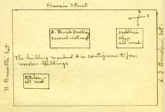
In 1846 another insurance policy (#14,392 revaluation of building formerly declared for Assurance by Lucius F. Cary per Declaration #8586) in the name of Richard H. Graves describes the property as "My Building on my own land in Williamsburg now occupied by myself and H. W. Lee situated between the lot of 5 Richard Bassett on the West, lots of Lemuel J. Bowden on the East and Francis Street North in the county of James City. The Dwelling marked A at $800 Brick covered with wood ... contiguous to four wooden buildings Saddlers shop all wood [to the east] Kitchen - all wood [to the southwest]". (Copy of policy, Illustration #3)
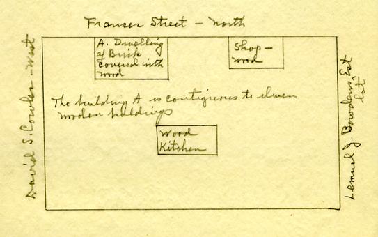
In 1853 Graves insured his property under policy (#17,634) revaluation of building declared for Assurance per Declaration #14,392 thus: " ... My Building on Frances Street now occupied by myself situated between the lots of Richard Bassett's estate on the West and Lemuel J. Bowden on the East in the county of James City... The Dwelling marked A at $1000 of Brick covered with wood contiguous to eleven wooden buildings Shop, wood , [to east] Wood Kitchen [to rear]" (Illustration #3 for copy)
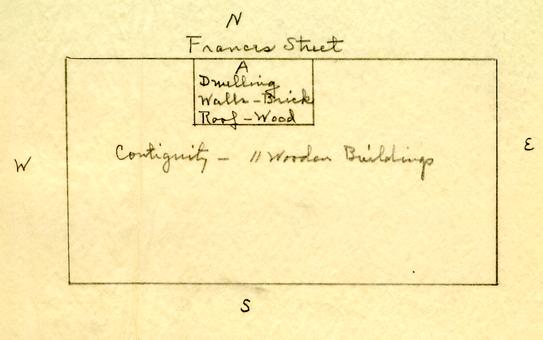
In 1860 Graves again insured the property under policy (#21,333) revaluation of building formerly declared for Assurance per Declaration #17,634, thus: "...My Building on the South side of Frances Street now occupied by Myself situated between the lots of Richd Bassett's est. on the West and that of Lemuel J. Bowden on the East in the Said City of Williamsburg and in the county of James City... The Dwelling marked A at $800 Walls-Brick Roof-Wood contiguity - 11 Wooden Buildings." (Illustration #3, copy) See Illustration #2 for complete tax list to this date with valuations of this property.
The land tax records provide an unbroken title of Richard H. Graves during the years 1841 to 1902. In 1902, the heirs of Richard H. Graves conveyed the property to Henry K. Graves. On June 14, 1928 Henry K. Graves and wife convey the property to W. A. R. Goodwin representing Williamsburg Restoration. (See: abstract prepared by V. M. Geddy, July 9, 1928 -Accounting Department, Colonial Williamsburg)
Mrs. Victoria M. Lee in her recollections, "Williamsburg in 1861" (written 1929) described the Graves property as follows: "The Graves owned and occupied a small brick house that was next to the present Sweeny house. This house has 6 been added to so often and a large front porch has taken the place of a small platform entrance, that it does not look the least bit now as it did during the War." (copy, Research Department)
IN SUMMARY:
In 1785 William Hornsby conveyed 4 lots to George Carter. It seems probable that the lots were owned by Colonel James Innis in 1782 or before. The Frenchman's Map (1782) shows no buildings upon the lots. The College Map (1791?), the Galt Map drawn by Browne (1780?) and the Bucktrout Map (1803) show "G. Carter" on the two lots on the south side of Francis Street. In 180? Philip Moody was occupying the property "east of Ewing". In 1809 Anthony Robinson had acquired the property thus: "via Carter". In 1815 John Bracken was the owner of a block of 8¼ lots "via Anthony Robinson and wife." In 1817 Bracken sold 1 acre - lot to Thomas Sands Sr. who held the property until 1837 when Lucius F. Cary became the owner. Cary insured the property as "A. Dwelling House of Brick covered with wood 26 by 18 two stories high shed & Porch to Dwelling of wood entire 18 by 11. one story high." A short period of ownership by Scervant Jones (1839-41) was followed by Richard H. Graves. From 1841 to 1902 there is an unbroken chain to title in the Graves family. During this time (in 1846, 1853 and 1860)1 Graves insured the property. In each case the dwelling is described as of brick covered with wood. In 1846 (policy #14,392) indicates that a "saddler's shop all wood" was east of the brick dwelling. Mrs. Victoria M. Lee describes the Graves property as she recalled it in 1861 thus: "The Graves owned and occupied a small brick house that was next to the present Sweeny house. This house has been added to so often and a large front porch has taken the place of a small platform entrance, that it does no look the least bit now as it did during the War." In 1928 the property was conveyed by Henry K. Graves to W. A. R. Goodwin representing Williamsburg Restoration. Further detail of the ownership from 1928 to 1949 can be found 7 in abstract prepared by V. M. Geddy, July 9, 1928, Accounting Department, Colonial Williamsburg.
Mary A. Stephenson
Research Department
(Report prepared by Mary A. Stephenson, Research Assistant)
Prepared - November, 1949
Typed - November, 1949
Footnotes
| "1795 | George Carter | 10 slaves, 3 horses, 4 wheels |
| 1797 | George Carter | 9 slaves, 1 horse |
| 1798 | George Carter | 9 slaves, 1 horse, 1 coach, 1 chair |
| 1801 | George Carter | 10 slaves, 3 horses, 1 coach |
| "August 10, 1799 gave my Bonds to | |
| Samuel Tyler 1 payable April 15, 1800 at | £290. |
| 2d payable Octr 15, 1800 at | 290. |
| £580. |
These Bonds given as a consideration for the Lotts & Houses in Williamsburg Purchased by him for me of George Carter, the House wherein Carter now lives & wch were formerly John Byrds -- also for a 151 acres of land in York County ... 2 or 4 miles from Wmsburg, wch Carter purchased of John Coke."
A John Byrd according to the Land Tax Records held in 1788 "4 lots bought of William Finnie and Archibald Diddip. Diddip's lot is described in 1773 as "contiguous to Dr. Pasteur's." John Byrd's house on Francis Street is described in 1789 thus:
November 4, 1789.
"To be SOLD; or RENTED the ensuing year, THE HOUSE at present occupied by Mr. Smith, fronting Francis Street, and adjoining the capitol square, nearly opposite to John Byrd, Esq.
JAMES GALT." (Virginia Independent Chronicle, and General Advertiser)
Appendix #1
Graves Lots Francis Street
 PHOTOSTAT COPY OF THE WILLIAMSBURG PLAT IN "WILLIAMSBURG, THE OLD COLONIAL CAPITOL" BY LYON G. TYLER
FROM FRENCHMAN'S MAP 1782?
Illustration #2
G. Carter Lot
Williamsburg Land Tax Records
| 1782 | ----- James Innis | ----- 4 lots | ----- £ 4 | |
| 1785 | ----- William Hornsby | -----4 lots | ---- £ 4 | bought of James Innis |
| 1786 | ----- George Carter | ----- 4 lots | via William Hornsby | |
| 1791 | ----- George Carter | ----- 4 lots | ----- £12 | |
| 1797 | ----- George Carter | ---- 4 lots | ----- £12 | |
| 1806 | ----- Anthony Robinson | ------ 6 ¼ lots | via Moody | |
| 1809 | ----- Anthony Robinson | ----2 lots | via Carter ---- $10 | |
| 6 ¼ lots | ---- $100 | |||
| 1815 | ----- John Bracken | ----- 8 ¼ lots | via Anthony Robinson & wife Certain Houses & lotts of land -- $120 | |
| 1817 | -----John Bracken | ----- 8 ¼ lots | ----- $140 | |
| 1818 | ----- Thomas Sands Sr | ---- 3 ½ lots | ----- $245 | 1 Via John Bracken, one acre of land on the south side of Francis Street. |
| 1824 | ----- Thomas Sands | ---- 1 lot | ----- $800; | lot & buildings $975 Reassessed: new building estimated at $700 |
| 1838 | ----- Lucius F. Cary | ----- 1 lot via Thomas Sands | ----- $800; | lot & buildings $975 |
| 1839 | ----- Scervant Jones | ----- 1 lot | via Lucius F. Cary In fee $800; lot & buildings $975 | |
| 1841 | ----- Scervant Jones | ----- 1 lot | ----- $1000; | lot & buildings $1500 to Richard H. Graves |
| 1843 | ----- Richard H. Graves | ----- 1 lot | ----- $1000; | lot & buildings $1500 via Scervant Jones |
| 1843-54 | -- Richard H. Graves | ------ 1 lot | ----- $900; | lot & buildings $1200 |
| 1859 | ----- Richard H. Graves | ----- 1 lot | ----- $900; | lot & buildings $1200. |
[Note: The entire block of lots of John Bracken is listed (8¼) and also all of Thomas Sands' property in order to show what happened to the small lot, subject of this report.]
Illustration #3
G. Carter Lot
Block #2
Mutual Assurance Society Policy #8586
1837, August 29th
Lucius F. Gary residing at Williamsburg in the county of James City do hereby declare for assurance... my building on Frances Street now occupied by Jenny Johnson situated between the lands of George McCandlish on the East and Ebenezer Ewings estate on the West in the County of James City...
The Dwelling House marked A at $900

Mutual Assurance Society Policy #14,392 revaluation of Building formerly declared for Assurance by Lucius F. Cary per Declaration #8586 1846, October 3. Richard H. Graves residing at Williamsburg in the county of James City do hereby declare for Assurance... my building on my own land in Williamsburg now occupied by myself and H.W. Lee situated between the lot of Richard Bassett on the West, lots of Lemuel J. Bowden of [on] the East and Francis street North in the county of James City.
The Dwelling...marked A at $800
Mutual Assurance Society policy #l7,634 Revaluation of Building formerly declared for Assurance by Richard H. Graves per Declaration #1?
1853, November 28th . ...
Richard H. Graves residing at Williamsburg in the county of James City do hereby declare for Assurance ... my Building on Frances Street now occupied by myself situated between the lots of Richard Bassett's estate on the West, and Lemuel J. Bowden on the East in the county of James City... The Dwelling marked A at $1000
Mutual Assurance Society policy #21333 Revaluation of
Building formerly declared for Assurance by Richard H. Graves per Declaration #17634
1860, December 31st.
... Richard H. Graves residing at Williamsburg in the county of James City do hereby declare for Assurance ... my building on the South side of Frances Street now occupied by Myself situated between the lots of Richd Bassett's est. on the West and that of Lemuel J. Bowden on the East in the said City of Williamsburg and in the county of James City... The Dwelling marked A at $800